

What this entry found
- OUTLETS DISAGREE
Maximum sustained wind speed of Typhoon Saudel as of August 25, 2026
- moneycontrol.com (115 mph / 185 km/h)
- moneycontrol.com social media quote (165 km/h)
- OUTLETS DISAGREE
Classification of Typhoon Saudel at time of reporting
- moneycontrol.com (described as powerful typhoon, expected to remain powerful)
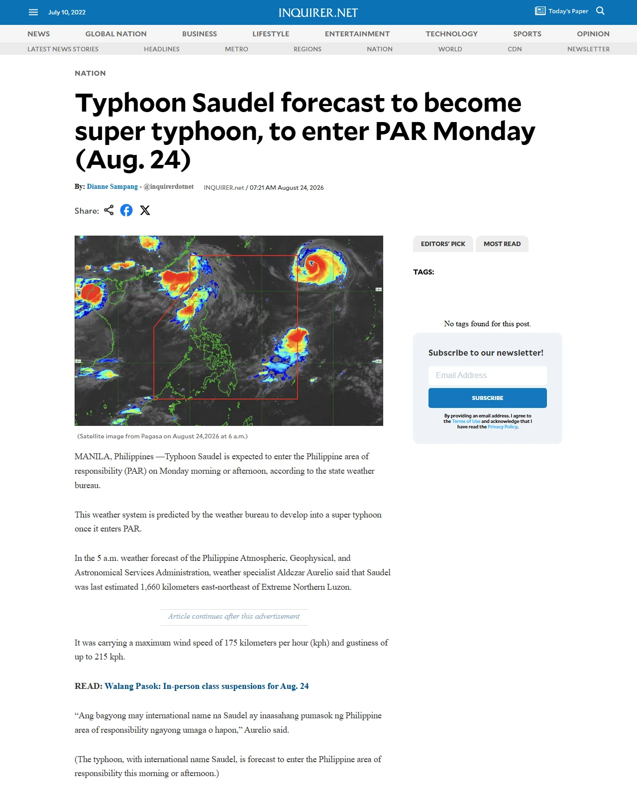
- newsinfo.inquirer.net (forecast to become super typhoon once entering PAR)
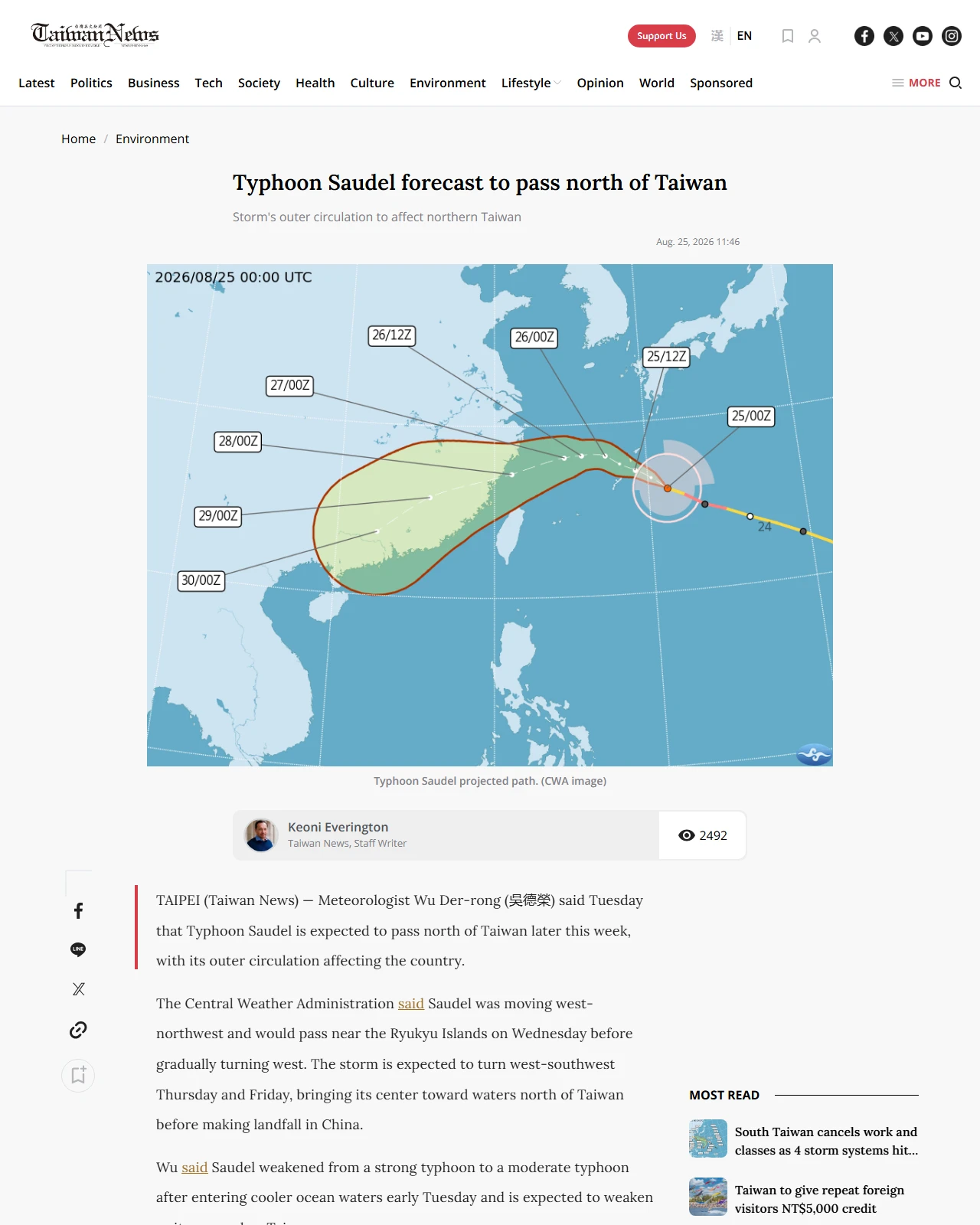
- taiwannews.com.tw (weakened to moderate typhoon by early Tuesday)
- ONLY ONE OUTLET HAD THIS
taipeitimes.com carried 4 details no other outlet reported.
- Tigerair announced flights between Taiwan Taoyuan and Naha (IT232, IT233), between Kaohsiung and Naha (IT288, IT289, IT728), and from Naha to Taichung (IT793) were moved up on August 25, 2026
- China Airlines canceled flights CI312, CI313 (Taichung-Naha), CI132, CI133 (Kaohsiung-Naha), and suspended flights CI310, CI311 (Taichung-Naha) and CI120, CI121 (Taoyuan-Naha) for August 25 or 26, 2026, while moving up flights CI310, CI311 and CI122, CI123
- Starlux Airlines rescheduled flights JX870, JX871 (Taoyuan-Naha) and JX302, JX303 (Taichung-Naha) to depart earlier on August 25, 2026, and suspended JX312, JX313 (Taichung-Naha) that afternoon
- Airlines announced flight cancellations and rescheduling in response to Typhoon Saudel
Day name corrected
The summary below named a weekday that does not match its own date. The date is as written; only the day name was recomputed from it.
Wednesday, August 27→ Thursday, August 27Tuesday (August 26, 2026→ Wednesday (August 26, 2026
Typhoon Saudel approached East Asia in late August 2026, with maximum sustained winds reported between 165–185 km/h. The system was forecast to affect the Ryukyu Islands, Taiwan, and the Philippines, with impacts including severe waves, flight disruptions, and potential landfall in China. Various weather services and airlines provided forecasts and operational responses as the storm moved west-northwest across the region.
Who reported it
- moneycontrol.comUNCLASSIFIED
- newsinfo.inquirer.netUNCLASSIFIED
- taipeitimes.comUNCLASSIFIED
- taiwannews.com.twUNCLASSIFIED
References
- moneycontrol.comTyphoon Saudel 2026 in Japan: 185 km/h winds head towards Okinawa as scientists warn of destructive...Screenshot as publishedOriginalcaptured 2026-08-25T13:46:32
- newsinfo.inquirer.netTyphoon Saudel forecast to become super typhoon, to enter PAR Monday (Aug. 24)Screenshot as publishedOriginalcaptured 2026-08-25T13:46:32
- taipeitimes.comTyphoon Saudel disrupts today’s flights between Taiwan, OkinawaScreenshot as publishedOriginalcaptured 2026-08-25T13:46:32
- taiwannews.com.twTyphoon Saudel forecast to pass north of TaiwanScreenshot as publishedOriginalcaptured 2026-08-25T13:46:32
Carried by multiple outlets
- Typhoon Saudel was moving west-northwest toward the Ryukyu Islands and Okinawa region as of August 25, 2026moneycontrol.com, taipeitimes.com, taiwannews.com.tw
- The typhoon was expected to affect or pass near the Ryukyu Islands and/or Okinawa on or around Thursday, August 27 or 28, 2026moneycontrol.com, taiwannews.com.tw
Reported by one outlet only
- Maximum sustained winds as of Tuesday were around 115 mph (185 km/h), with forecasts of potential weakening but retention of powerful typhoon status when reaching Okinawaonly moneycontrol.com
- Forecasts indicated waves around Okinawa could reach 11 metres (approximately the height of a three-story building) as Saudel approachesonly moneycontrol.com
- Heavy rainfall could trigger flooding, landslides and swollen rivers in the Okinawa regiononly moneycontrol.com
- The Philippine Atmospheric, Geophysical, and Astronomical Services Administration forecast Saudel to become a super typhoon once it entered the Philippine Area of Responsibility (PAR), with maximum wind speed of 175 kph and gustiness of up to 215 kph as of the 5 a.m. forecast on August 24, 2026only newsinfo.inquirer.net
- Saudel was last estimated 1,660 kilometers east-northeast of Extreme Northern Luzon according to Philippine weather authoritiesonly newsinfo.inquirer.net
- Philippine weather bureau forecast Saudel to exit PAR by Wednesday (August 26, 2026)only newsinfo.inquirer.net
Reported unevenly
- Maximum sustained wind speed of Typhoon Saudel as of August 25, 2026stated by moneycontrol.com (115 mph / 185 km/h), moneycontrol.com social media quote (165 km/h) · absent from newsinfo.inquirer.net (175 kph as of August 24, 5 a.m. forecast)
- Classification of Typhoon Saudel at time of reportingstated by moneycontrol.com (described as powerful typhoon, expected to remain powerful), newsinfo.inquirer.net (forecast to become super typhoon once entering PAR), taiwannews.com.tw (weakened to moderate typhoon by early Tuesday)
Not yet confirmed against a primary source
- Confirm the timeline: newsinfo.inquirer.net headline says 'Monday (Aug. 24)' and body references 'August 24' and 'August 25 forecast.' The article's publication date is not provided. If published before Monday August 25, 2026, the PAR entry date is August 26 ('tomorrow, Tuesday'). Verify whether the forecast was issued on August 24 or August 25, 2026.
- Confirm whether the maximum sustained wind measurements (115 mph/185 km/h from moneycontrol.com, 165 km/h in the same outlet's social media quote, and 175 kph from newsinfo.inquirer.net) all refer to the same time point (claimed to be August 25 or August 24) or whether they represent different forecast cycles from different meteorological services with different measuring standards.
What was checked, and against what
1 of 2 confirmed against a primary source. Every document is linked so you can read the same record we did. Anything not confirmed is listed as such rather than left out.
- checked 24)' and body references 'August 24' and 'August 25 forecast.' The article's publication date is not provided. If published before Monday August 25, 2026, the PAR entry date is August 26 ('tomorrow, Tuesday').primary source · establishes that the outlet published it · 25 August 2026 was a Tuesday, not a Monday. · 2026-08-25
- not checked Confirm whether the maximum sustained wind measurements (115 mph/185 km/h from moneycontrol.com, 165 km/h in the same outlet's social media quote, and 175 kph from newsinfo.inquirer.net) all refer to the same time point (claimed to be August 25 or August 24) or whether they represent different forecast cycles from different meteorological services with different measuring standards.would be answered by Official sources, general search